


무기 토론방
중국, 한국 및 일본 쪽으로 초장거리 레이더 추가 설치
출처
https://www.defensenews.com/global/asia-pacific/2022/04/18/new-chinese-radar-looks-towards-japan-satellite-image-shows/
2022-04-19
New Chinese radar looks toward Japan, satellite image shows
중국의 새로운 레이더가 일본 쪽을 향하고 있음을 위성 사진이 보여주고 있다
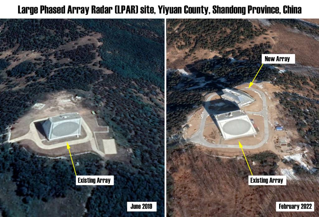
The February 2022 image shows a new radar panel added to an existing early-warning sensor in China's eastern Shandong province. (Maxar Technologies/Google Earth)
2022년 2월 사진은 중국 동부 산둥성의 기존 '초장거리 조기경보레이더'에 이어서 새로운 레이더가 추가된 것을 보여준다. (맥사 테크놀로지/구글 어스)
Large Phased Array Radar [LPAR] site, Yiyuan County, Shandong Province, China
중국 산둥성 이위안 현에 위치한 '초장거리 조기경보레이더(LPAR)' 기지
Existing Array : 기존 레이더
New Array : 새로운 레이더
June 2019 : 2019년 6월 사진
February 2022 : 2022년 2월 사진
A satellite photo has revealed that China has built a new long-range, early-warning radar that can be used to detect ballistic missiles from thousands of miles away, likely giving it coverage of all of Japan.
위성 사진에 따르면 중국은 수천 마일 떨어진 곳의 탄도 미사일을 감지하는 데 사용되는 새로운 '초장거리 조기경보레이더'를 설치하여 일본 전역을 탐지할 수 있게 된 것으로 보인다.
The image, taken on February 2022 by commercial satellite imagery company Maxar Technologies and published on Google Earth, show that a new Large Phased Array Radar, or LPAR, has been built at an existing mountaintop site in Yiyuan County, Shandong Province, some 70 miles southeast of the provincial capital Jinan.
상업용 위성사진업체 맥사 테크놀로지가 2022년 2월 촬영해 구글 어스에 게재한 이 사진은 산둥성 지난시에서 남동쪽으로 약 70마일 떨어진 이위안 현의 산꼭대기에 자리 잡은 기존 레이더 기지에 새로운 '초장거리 조기경보레이더(LPAR)'가 건설되었음을 보여준다.
The new array is pointed in a northeasterly direction and was built sometime after November 2019. Its completion can potentially give China early warning of ballistic missile launches from North and South Korea, most of Japan and even parts of Russia’s Far East.
이 새로운 '초장거리 조기경보레이더(LPAR)'는 북동쪽 방향을 가리키며 2019년 11월 이후에 건설된 것으로 보인다. 이 LPAR는 중국이 남한과 북한, 일본 대부분 지역, 심지어 러시아 극동 지역에서 발사되는 탄도 미사일에 대해서 조기 탐지 능력을 갖추도록 해준다.
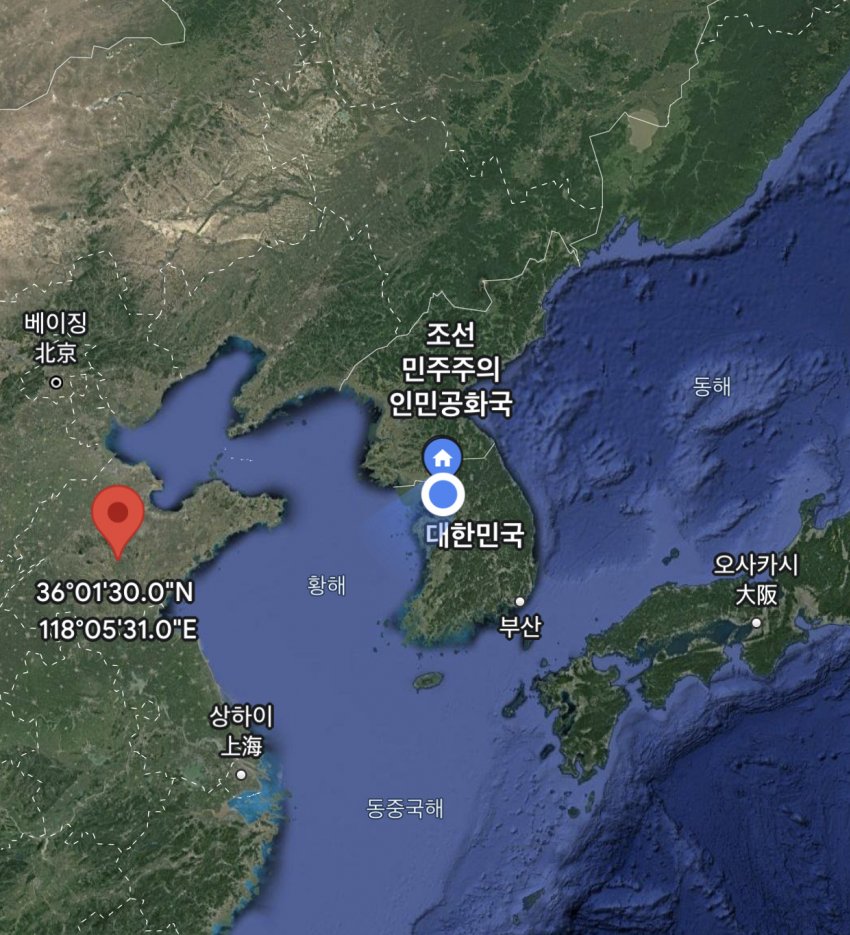
중국 산둥성 이위안 현에 위치한 '초장거리 조기경보레이더(LPAR)' 기지의 위치
The first LPAR at the site, located at 36°01′30″ N, 118°05′31″ E, is some 2,300 feet above sea level. It was finished sometime in 2013-2014 according to Google Earth’s historical imagery and is oriented toward the south-southeast, almost certainly to provide radar coverage of Taiwan.
이 레이더 기지의 첫 번째 LPAR은 북위 36도 01분 30초, 동경 118도 05분 31초 위치에 있으며 해발 고도는 약 2,300피트다. 구글 어스의 과거 이미지에 따르면 2013~2014년 사이에 완공되었으며 대만 쪽을 탐지하기 위해서 남동쪽으로 향하고 있다.
China is also known to operate additional LPAR sites at Lin’an in Zhejiang Province and Heilongjiang Province. These sites enable early warning coverage of Japan, the Korean Peninsula and Taiwan from multiple angles.
또한 중국은 저장성 린안과 헤이룽장성에서도 LPAR 레이더 기지를 추가로 운영하는 것으로 알려졌다. 이 레이더 기지들은 일본, 한반도, 대만에 대해서 여러 각도에서 조기 탐지 능력을 갖추도록 해준다.
Another site at Korla in Xinjiang Province provides early warning coverage of India. In addition to providing warning against ballistic missile launches, LPARs can also be used for satellite tracking and general space surveillance.
신장 위구르 자치구의 쿠얼러에 위치한 또 다른 LPAR 레이더 기지는 인도에 대해서 조기 탐지 능력을 갖추도록 해준다. LPAR은 탄도 미사일 발사에 대해서 경보를 알려주는 것 외에도 위성 추적과 통상적인 우주 감시에도 사용될 수 있다.
The capabilities of the Chinese LPARs are not known, although the beam of the similar AN/FPS-115 radar found in the U.S. Pave Paws network can be deflected up to 60 degrees from the array’s central boresight axis, allowing each array to cover an azimuth angle of 120 degrees.
중국 LPAR의 자세한 능력은 알려지지 않았지만, 미국의 위상배열 경보체계(PAVE PAWS)에서 쓰이는 LPAR에 속하는 AN/FPS-115 레이더는 중심 조준 축을 기준으로 60도 범위를 커버할 수 있어 각각의 레이더는 탐지할 수 있는 방위각이 120도에 달한다.
Previously released photos of China’s LPARs show that the array is also sloped, similar to that of the AN/FPS-115 which is sloped at an angle of 20 degrees, allowing the beam to be directed at any elevation angle between 3 degrees and 85 degrees.
이전에 공개된 중국의 LPAR 사진을 보면, AN/FPS-115 레이더와 비슷하게 20도 각도로 기울어져 있어 레이더빔이 3도에서 85도 사이의 모든 고도 각으로 향할 수 있다.
The range of the Pave Paws radar network has not been officially published, although Encyclopedia Britannica says that the system “is supposed to detect targets with a radar cross section of 10 square meters at a range of 3,000 nautical miles (5,600 km)”.
중국 위상배열 경보체계(PAVE PAWS) 레이더의 탐지 거리는 공식적으로 알려진 게 없지만, 브리태니커 백과사전에 따르면 이 시스템은 3,000 해리(5,600 km) 범위에서 단면적이 10제곱미터인 표적을 탐지하는 것으로 추정된다고 한다.
China has invested considerably in advancing its capabilities for strategic situational awareness as part of its sweeping overall military modernization program. The country’s LPARs are an integral part of China’s early-warning, missile-defense and space-tracking network, which also includes a growing number of space-based sensors and a network of over-the-horizon radars.
중국은 전면적인 군 현대화 정책의 일환으로 장거리 탐지 능력을 향상하는 데 상당한 투자를 해왔다. LPAR은 중국의 조기 경보 체제, 미사일 방어, 우주 추적 네트워크의 필수적인 부분이며, 중국의 장거리 탐지 능력 향상에는 점점 더 많이 배치되는 우주 기반 센서와 초수평선 레이더 네트워크도 한몫하고 있다.
-----------------------------------------------------------------------------------
중국 산둥성 지난시에서 남동쪽으로 약 70마일 떨어진 이위안 현에 자리 잡은 초장거리 레이더 기지를 찍은 민간위성 사진인데
2018년에는 대만 방향(남동쪽)의 레이더만 설치되어 있었으나,
2022년에는 일본 및 한국 방향(북동쪽)으로 추가 설치된 것이 확인됨.
(위치 좌표: 북위 36도 01분 30초, 동경 118도 05분 31초)
2019년 11월 이후에 해당 레이더가 설치된 것으로 보임.
이를 통해 일본 및 한국의 전역과 러시아 극동지역 감시가 가능하게 되었다고 함.
-

- best기갑군 (59.22.xxx.xxx)
- 2022-04-20 09:05:35
- 문재인은 당장 사드 3불 치욕을 철회하라!!!!!
-
- 드리머21 (125.176.xxx.xxx)
- 2022-04-23 01:26:34
- 밑에 중국집 왕서방이 글을 올렸나 봐요. 사드를 선제타격용 무기라느니, 우리 국가원수를 군 미필자로 폄하하질 않나, 중국이 레이다파를 우라에게 쏴주니 그게 그렇게도 항송하드냐? 대통령 경력자기 대통령을 하냐? 교사출신만이 교육부장관을 해야 하는거네, 네 똘같은 논리에 의하면 말야,
궁금할 거 없어, 네 고행인 중국으로 이민이나 쳐 가라구,
-
- 드리머21 (125.176.xxx.xxx)
- 2022-04-22 06:25:54
- 방어목적 레이더 가지고도 내정간섭, 시비걸고 천문학적인 경제보복을 했던 내로남불 중공이 저러는 거 어제 오늘인가요?
문제는 중공따까리 자처하는 한국내 내로남불 친중따까리정권이 문제입니다.
레이더 군사목적 아닌가요? 데응차원에서 우리도 추가설치해야 합니다.
-
- 투팍아마루 (150.197.xxx.xxx)
- 2022-04-21 09:32:03
- 신임정부에서 사드 추가 도입하나요? 선제타격 하려나? 군통수권자 본인이 미필에, 군에 대해 지식이 전무한것 같던데, 어떻게 대응할지 궁금하네요.
-
- 기갑군 (59.22.xxx.xxx)
- 2022-04-20 09:05:35
- 문재인은 당장 사드 3불 치욕을 철회하라!!!!!


